





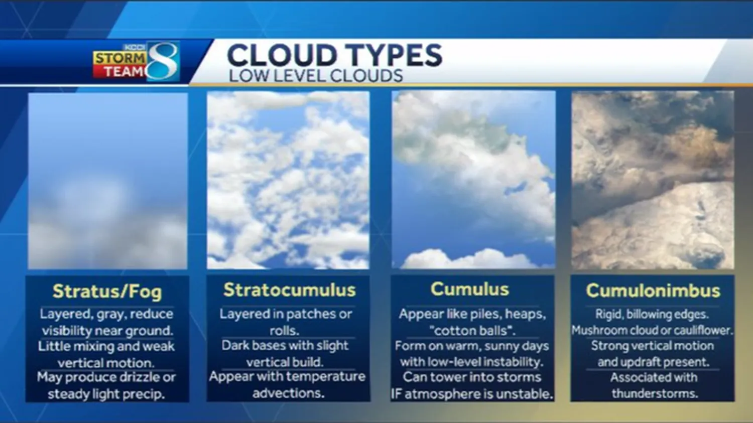
Learning how to identify different types of storm clouds is a vital skill for anyone interested in home safety, outdoor activities, or severe weather tracking. The atmosphere gives clear warnings long before lightning strikes or torrential downpours hit your neighborhood. Just like mastering how to predict rain by looking at cloud formations gives you an edge over local systems, recognizing specific storm cloud structures helps you prepare for hazardous shifts in the weather.
The King of Storms: Cumulonimbus Clouds
You cannot study how to identify different types of storm clouds without focusing heavily on the **Cumulonimbus** cloud. These massive cloud networks are the only formations capable of producing hail, intense thunder, dangerous lightning flashes, and destructive tornadic funnels.
Cumulonimbus clouds grow via powerful convective updrafts that push moisture thousands of feet high into the upper atmosphere. When the top of the rising column hits stable thermal layers, it spreads out laterally to create a flattened, smooth shape known as an **anvil top**. If you spot an anvil-topped cloud moving toward your town, a powerful storm front is active and headed your way.
Identifying Low-Level Formations: Shelf Clouds vs. Wall Clouds
When storms get closer, amateur storm spotters often confuse two critical cloud features that have entirely different safety implications. Knowing how to tell them apart is crucial when assessing live weather changes.
| Cloud Feature | Visual Appearance | Primary Danger Type |
|---|---|---|
| Shelf Cloud | Horizontal wedge attached to the storm front's lower leading edge. | Severe straight-line winds and rapid downpours. |
| Wall Cloud | Localized downward drop beneath the storm’s rear rain-free base. | Potential rotation and tornado development. |
A shelf cloud is pushed forward by cold air rushing out of a rain cell, signaling an immediate blast of cold air. In contrast, a wall cloud forms where warm air is actively being sucked up into the center of the storm. If you notice a wall cloud rotating, seek shelter immediately. Tracking these severe convective features relies on the same core principles used when learning how to track the movement of a hurricane on a map across global coordinate zones.
Unique Visual Warnings: Mammatus and Asperitas
The atmosphere also creates unique, highly textured formations that look spectacular but indicate intense turbulence aloft. Understanding these anomalies helps build your overall storm spotting skills:
- Mammatus Clouds: These appear as smooth, pouch-like sacs hanging down from under the main anvil of a cumulonimbus cloud. They form when pockets of cold air saturated with water drop downward against rising warm air columns, signaling that a storm has just passed or is highly volatile.
- Asperitas Clouds: Known for their chaotic, wave-like structures, these clouds look like the rolling surface of a rough sea viewed from below. They feature dark, dramatic patterns but usually break up without producing severe tornadoes or major damage.
If you enjoy building small household tools to track weather elements, like the simple setups shown in our guide on how to make a DIY rain gauge for school projects, combining sky observations with physical instruments provides a fun, hands-on learning experience.
Key Atmospheric Signals to Watch
Observing cloud shapes is much more effective when you pay attention to the environment around you. For example, sudden drops in local pressure often accompany the growth of massive storm systems. Learning how to read a barometer to predict weather changes gives you a precise way to verify the cloud developments you see outside.
Additionally, note how quickly cloud bases are moving or shifting direction. Fast-moving cloud layers spinning around a central point mean high wind shear is active. This is a primary driver behind severe weather systems, similar to the global wind currents discussed in our guide on how to explain the greenhouse effect to a child.
Frequently Asked Questions
What does a green tint in storm clouds mean?
A deep greenish-charcoal color means the cloud contains a massive amount of water droplets and ice crystals. This ice scatters light in a specific way, frequently indicating that heavy hail or a tornado is possible.
Can a shelf cloud produce a tornado?
Shelf clouds rarely produce tornadoes because they form along a downward blast of cold air. They are known for causing strong straight-line winds that can blow down trees and damage power lines instead.
How fast do cumulonimbus storm clouds grow?
Under unstable atmospheric conditions, a small cumulus cloud can explode into a towering 40,000-foot cumulonimbus storm in less than 30 minutes, turning a clear day into a severe weather situation very rapidly.
Conclusion: Staying Ahead of the Storm
Mastering how to identify different types of storm clouds makes it easy to read the sky's natural warning signs. By identifying high anvil tops, checking for rotating low-level wall bases, and watching color shifts, you can tell the difference between a passing shower and a dangerous storm. For official up-to-date severe alerts and safety guidelines, always consult the National Weather Service (NWS) to keep your family safe during active weather seasons.