





Executive Summary: The Ultimate 7-Day East African Circuit
Combining the dramatic volcanic topography of northern Tanzania’s Crater Highlands with the vast, endless savannas of the Serengeti National Park within a tight 7-day window is one of Africa’s premier travel experiences. However, achieving this without spending half your vacation stuck in a dusty, corrugated vehicle requires absolute precision in route design, park permit synchronization, and flight management. This guide breaks down exact drive schedules, hidden trekking logistics, financial cost sheets, and seasonal animal movements.
1. Why Combine the Crater Highlands & Serengeti?
Many first-time travelers to East Africa make the fundamental mistake of viewing Northern Tanzania solely through the narrow lens of a traditional vehicle-bound safari. While sitting in a 4x4 cruiser traversing endless dirt tracks offers magnificent views, relying exclusively on standard game drives often overlooks the extraordinary ecological and geographical contrast offered by combining the Crater Highlands with the iconic Serengeti National Park.
Rising dramatically above the arid floor of the Great Rift Valley, the Crater Highlands (officially situated within and surrounding the Ngorongoro Conservation Area) form a breathtaking chain of extinct, dormant, and active volcanic structures. This geologically unique ridge includes world-renowned landforms such as the Ngorongoro Caldera, Empakaai Crater, Olmoti Crater, and the active strato-volcano Ol Doinyo Lengai—revered by the local pastoralist communities as the "Mountain of God" in the Maa language.
By pairing the volcanic ridges, cloud-shrouded montane rainforests, and high-altitude alpine moorlands of the highlands with the boundless grasslands of the Serengeti savanna, you construct a balanced, dynamic, and physically engaging 7-day expedition. Instead of enduring day after day of vehicle fatigue, this hybrid approach blends active rim hiking, cultural trekking, and intense predator tracking into one seamless journey.
The Geological & Ecological Contrast
The transition from the high-altitude volcanic ridges of the Crater Highlands down into the massive, sun-baked basin of the Serengeti represents one of the most dramatic ecological and geological landform shifts on earth. Over a direct driving distance of under 100 kilometers, travelers drop over 900 vertical meters—descending from the cold, moisture-laden, cloud-draped rim of Ngorongoro (hovering above 2,400 meters elevation) down to the sweeping short-grass savanna of the Central Serengeti (resting around 1,500 meters above sea level).
This steep decline in elevation creates a distinct rain shadow effect and dramatically reshapes local microclimates, vegetation structures, wildlife adaptations, and human land usage across Northern Tanzania:
-
Montane Cloud Forests & Alkaline Crater Lakes:
The eastern and southern slopes of the Crater Highlands catch moist air masses sweeping inland from the Indian Ocean. As these air currents collide with volcanic peaks rising over 3,000 meters, they cool and condense, producing persistent mountain fogs, heavy rain, and dense, evergreen montane rainforests dominated by giant tree ferns, wild fig trees, and yellowwood.
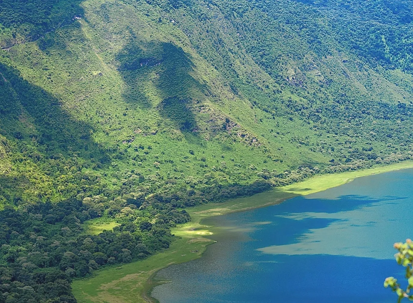
Deep within isolated volcanic calderas—such as the dramatic 6-kilometer-wide Empakaai Crater—lie deep soda lakes. Rich in sodium carbonate, these alkaline waters support thriving blooms of blue-green algae (spirulina), attracting tens of thousands of lesser flamingos that line the emerald water’s edge in vibrant pink ribbons visible from high above the forest-clad rim. -
The Serengeti Volcanic Grassland Basin:
Moving westward past Oldupai Gorge, the dense forest canopy disappears abruptly, replaced by sparse acacia scrubland and the famed "endless plains" (derived from the Maa word Siringit). Millions of years ago, ash plumes erupted from nearby volcanoes—including Ngorongoro, Olmoti, and Kerimasi—blanketing this entire basin in thick ash deposits rich in phosphorus, calcium, and sodium.
These mineral-dense soils formed a hardpan layer (caliche) under the ground, preventing deep root structures of tall trees from growing and creating the iconic short-grass plains. It is this precise mineral richness in the grass that fuels the Great Wildebeest Migration, drawing over 1.5 million wildebeest, 250,000 plains zebras, and dense populations of apex predators (lions, leopards, and cheetahs) across seasonal tracking routes.
Geological Origins: Rift Valley Tectonics & Ancient Granitic Kopjes
The landscape of the Serengeti and Crater Highlands is a story written by active plate tectonics. As the East African Rift system continues pulling tectonic plates apart, magma forced its way to the surface, constructing massive shield volcanoes and calderas millions of years ago. Simultaneously, wind and water erosion swept away surface volcanic ash across the Serengeti, exposing ancient, 450-million-year-old granitic rock outcrops known as kopjes. These "islands in a sea of grass" collect water in rock hollows and act as vital hunting lookouts and shade refuges for big cats.
Microclimate & Temperature Shifts
Travelers making this transit must prepare for wild temperature fluctuations within a single day's drive:
- Highland Rim (Ngorongoro / Empakaai): Nighttime and early morning temperatures frequently plummet to between 5°C and 10°C (41°F – 50°F), with heavy dew, thick fog, and high humidity wrapping through the highland forest. Warm fleece layering, windbreakers, and thermal wear are essential for rim walking.
- Serengeti Savanna Plains: Daytime temperatures climb to 28°C – 33°C (82°F – 91°F) under direct equatorial sun, with low humidity and high dust conditions across open tracks. Sun protection, breathable cotton clothing, and polarized optics become necessary.
Wildlife Migration Dynamics Between Elevation Zones
The drastic change in landscape dictates animal movements throughout the year. During the wet season (December to April), the mineral-packed short-grass plains south of the Serengeti basin attract mega-herds for calving due to the high calcium content in the grass, which supports lactating wildebeest cows. As the dry season takes hold (May to October), these herds migrate north and west toward permanent river water catchments like the Mara and Grumeti Rivers, while resident highland game (buffaloes, bushbucks, and blue monkeys) remains anchored in the damp montane forests.
Important Itinerary Planning & Verification Links
To ensure your trip across these contrasting ecosystems is planned safely and efficiently, explore our related operational guides and verified planning resources:
- Evaluate drive vs. fly trade-offs on this route using our guide on How to Evaluate a Luxury Fly and Drive Safari Itinerary Breakdown.
- Ensure your tour operator is licensed before transferring deposits via our resource on How to Check if a Tanzanian Safari Company is Officially Registered and Licensed.
- Find recommended regional safari agencies in How to Find the Best Local Safari Companies in Moshi and Arusha.
- Compare top luxury lodge options and custom packages via How to Book Top Rated Luxury Safari Operators for Serengeti and Ngorongoro.
- Planning a romantic post-safari island retreat? Read our operational guide on How to Choose Honeymoon Safari Operators for a Combined Serengeti and Zanzibar Trip.
Key Expedition Synergy: Active Trekking Meets Wildlife Tracking
Spending your first two days hiking through the volcanic ridges allows your body to adjust to high altitudes, stretch out after long flights, and experience African wildlife on foot under the guidance of an armed ranger. Once fully immersed in nature, you transition smoothly into classic vehicle-based game drives across the Serengeti, giving you a comprehensive perspective on East Africa's diverse wilderness.
Cultural Heritage & The Coexistence Model
Unlike standard strict national parks, the Ngorongoro Conservation Area operates as a multiple land-use area. Here, indigenous Maasai pastoralists coexist with wild populations of zebras, gazelles, and giraffes. Hiking through the highlands offers authentic cultural interactions—walking alongside Maasai warriors along traditional cattle tracks, passing through traditional bomas (homesteads), and learning about indigenous botanical medicines—all far removed from tourist-heavy cultural shows.
Strategic Itinerary Links & Planning Resources
To design an efficient 7-day Northern Circuit route without burning out on travel days, review our related logistical guides and route planning blueprints:
- Evaluate drive vs. fly trade-offs in our detailed guide on How to Evaluate a Luxury Fly and Drive Safari Itinerary Breakdown.
- Verify tour operator credentials before booking through our resource on How to Check if a Tanzanian Safari Company is Officially Registered and Licensed.
- Find recommended local operators in How to Find the Best Local Safari Companies in Moshi and Arusha.
- Planning a special trip? Read our operational guide on How to Choose Honeymoon Safari Operators for a Combined Serengeti and Zanzibar Trip.
2. Route Logistics & Distance Breakdown
Understanding how to visit crater highlands and serengeti in 7 days requires balancing transit hours with actual wilderness viewing time. The Northern Circuit of Tanzania covers rough dirt roads between Karatu, the Ngorongoro Conservation Area (NCA), and the Serengeti interior. A drive-only itinerary leads to vehicle fatigue, whereas a hybrid fly-drive setup preserves energy for trekking and game tracking.
When organizing travel through Tanzania Wildlife Management Authority regions, matching vehicle drive speeds against conservation land entry rules is critical. If you are comparing overland options vs internal bush flights, check our breakdown on how to evaluate a luxury fly and drive safari itinerary breakdown to see where transit hours can be cut in half.
| Leg Sector | Distance (km) | Drive Time | Road Terrain Type |
|---|---|---|---|
| Arusha to Karatu | 140 km | 2.5 - 3 Hours | Smooth Smooth Tarmac Highway |
| Karatu to Loduare Gate (NCA) | 15 km | 20 - 30 Minutes | Paved to Corrugated Dirt |
| Loduare Gate to Crater Rim | 10 km | 25 Minutes | Winding Mountain Dirt (Moist) |
| Crater Rim to Nainokanoka / Olmoti | 25 km | 45 Minutes | Rough Gravel & Dirt Track |
| Crater Rim to Naabi Hill (Serengeti Entry) | 90 km | 2.5 - 3 Hours | Extremely Corrugated Gravel ("Washboard") |
| Naabi Hill Gate to Seronera (Central) | 50 km | 1 - 1.5 Hours | Dirt Savanna Tracks / Dirt Highway |
| Seronera to Kogatende (Northern Serengeti) | 115 km | 3.5 - 4.5 Hours | Unpaved Bush Trails / River Crossings |
4. 2026 Detailed Park Fees, Permits & Budget Estimates
Calculating the total cost of a combined Crater Highlands and Serengeti expedition requires navigating two distinct administrative bodies: the Ngorongoro Conservation Area Authority (NCAA) and Tanzania National Parks (TANAPA). Both agencies enforce strict 24-hour tariff windows, statutory 18% Value Added Tax (VAT), vehicle weight surcharges, and mandatory ranger fees.
Failing to plan these park fees correctly can result in unexpected double-charges or gate delays. A transparent breakdown of operational fees ensures you budget accurately whether you choose a mid-range overland drive or a high-end luxury fly-and-drive option.
Critical 24-Hour Billing Window Rule
Park entry permits operate strictly on a continuous 24-hour cycle from the moment your vehicle passes the entry gate. For example, if you clear Loduare Gate into Ngorongoro at 08:00 AM on Day 2, your entry pass expires at 08:00 AM on Day 3. Staying over by even 15 minutes triggers an entire extra day’s fee per person and vehicle.
| Authority / Category | Base Fee (USD) | VAT (18%) | Total Per Person / Unit | Billing Rule Details |
|---|---|---|---|---|
| NCAA Conservation Fee (Adult) | $70.00 | $12.60 | $82.60 | Per 24-hour period inside Ngorongoro land |
| NCAA Crater Service Fee | $295.00 | $53.10 | $348.10 | Per vehicle / single entry to crater floor |
| TANAPA Serengeti Entry Fee (Peak) | $70.00 | $12.60 | $82.60 | Per 24-hour period (July - March) |
| TANAPA Serengeti Entry Fee (Low) | $60.00 | $10.80 | $70.80 | Per 24-hour period (April - May) |
| Armed NCAA Trekking Ranger | $30.00 | $5.40 | $35.40 | Per walking trek group (up to 6 pax) |
| Concession / Camping Fees | $50.00 - $60.00 | $9.00 - $10.80 | $59.00 - $70.80 | Per person / night inside park lodges/tents |
| One-Way Bush Flight (Serengeti - Arusha) | $250.00 - $380.00 | Included | $250 - $380 | Per passenger including airport tax |
Budget vs. Mid-Range vs. Luxury Estimates
- Mid-Range Camping/Lodge Safari ($2,800 – $3,800 per person): Utilizes shared or private 4x4 vehicles, comfortable mid-tier tented camps, standard park permits, and a one-way bush flight back to Arusha.
- Luxury Fly-and-Drive ($5,500 – $8,500+ per person): Features premium small-scale tented camps, private high-end Land Cruisers, customized trekking services, and internal bush flight connections.
If you prefer a seamless, top-tier safari experience with high-end accommodations and direct bush flight logistics, read our guide on How to Book Top Rated Luxury Safari Operators for Serengeti and Ngorongoro. For couples planning a post-safari tropical getaway, check our operational breakdown on How to Choose Honeymoon Safari Operators for a Combined Serengeti and Zanzibar Trip.
5. Deep-Dive: Trekking the Crater Highlands Rim
Trekking across the volcanic geology of the Crater Highlands is one of the most rewarding wilderness walking experiences in East Africa. The high elevation provides cool mountain breezes, dramatic vistas of extinct calderas, and direct trails through ancient Maasai grazing territory.
Because these highland forests host big game—including free-roaming African buffaloes, elephants, leopards, and hyenas—walking here requires strict safety protocols, specialized equipment, and certified local escorts.
Essential Safety Regulations & Mandatory Armed Rangers
Walking safaris inside the Ngorongoro Conservation Area are strictly regulated by the Ngorongoro Conservation Area Authority (NCAA). Visitors are not allowed on foot trails without an official armed NCAA ranger. Armed rangers are trained in wildlife behavior management and lead every trek to protect hikers against surprise wildlife encounters in thick forest brush.
In-Depth Comparison of Major Highland Trails
1. Empakaai Crater Trail (High Intensity)
Empakaai is a dramatic collapsed volcano with a circular caldera 6 kilometers wide. The inner crater floor is almost entirely filled by a deep, hyper-saline soda lake (85 meters deep).
- Trail Elevation Profile: Begins on the rim at 2,700 meters above sea level and drops 300 vertical meters down to 2,400 meters on the caldera floor.
- Hike Experience: Descends through lush, moss-draped montane forest filled with wild orchids, strangler figs, and colorful bird species (including Hartlaub’s turaco). On the shoreline, tens of thousands of lesser flamingos gather in pink bands.
- Fitness Requirement: Moderate to high. The descent takes ~45 minutes, but the return uphill climb is steep and demanding, taking 1.5 to 2 hours.
2. Olmoti Crater & Munge Waterfall Trail (Moderate Intensity)
Olmoti is a shallow, grass-covered caldera that acts as a vital water catchment area feeding Lake Magadi inside the main Ngorongoro Crater.
- Trail Elevation Profile: Starts at Nainokanoka Maasai village (2,400 meters) and gently rises along cattle tracks up to the caldera rim.
- Hike Experience: Offers broad views across pastoral grasslands where Maasai herdsmen graze cattle side by side with elands and zebras. A trail leads to the northern rim wall where the Munge River cascades 100 meters down a sheer cliff face.
- Fitness Requirement: Easy to moderate (2 to 3 hours total round trip). Suitable for families and casual walkers.
3. Great Rift Valley Escarpment Trek (Empakaai to Leonotis / Lake Natron)
For serious hikers seeking multi-day wilderness trekking, this route descends off the high volcanic plateau down into the hot, dry floor of the Great Rift Valley near Lake Natron.
- Hike Experience: Offers sweeping vistas of the active volcano Ol Doinyo Lengai. You pass through remote Maasai settlements far off standard tourist circuits.
- Fitness Requirement: High endurance required. Demands proper trekking poles, sturdy boots, and hot-weather hydration management.
Working with reliable ground teams in Arusha ensures your rangers and permits are pre-booked seamlessly. Learn how to select certified regional agencies using our resource on How to Find the Best Local Safari Companies in Moshi and Arusha.
6. Optimizing Serengeti Game Time & Seasonal Tracking
Spanning nearly 15,000 square kilometers, Serengeti National Park is an expansive ecosystem divided into distinct geographic regions: Central (Seronera), Western Corridor, Northern (Kogatende), and Southern (Ndutu). To make the most of your 7-day trip, your itinerary must align with real-time wildlife movements and seasonal rainfall patterns.
Positioning your camp near current wildlife concentrations minimizes long transit drives and maximizes active game viewing time during golden hour light.
The Great Wildebeest Migration Calendar
More than 1.5 million wildebeest, 250,000 zebras, and hundreds of thousands of gazelles move constantly in a circular migration pattern driven by rainfall and fresh grass growth:
| Month Range | Primary Focus Region | Key Ecological Highlights |
|---|---|---|
| January – March | Southern Serengeti & Ndutu | Wildebeest Calving Season; heavy predator activity (cheetahs & hyenas) |
| April – May | Central Serengeti & Seronera | Green season; lower tourist crowds; excellent resident game and birding |
| June – July | Western Corridor & Grumeti River | Herds moving north; Grumeti River crossings and giant crocodiles |
| August – October | Northern Serengeti (Kogatende) | Dramatic Mara River crossings; massive herds shifting between Tanzania & Kenya |
| November – December | North-Eastern & Central Serengeti | Short rains bring herds back south across the eastern migration corridors |
Optimizing Daily Game Drive Schedules
- Dawn Patrols (06:00 AM – 09:00 AM): Predators such as lions, leopards, and cheetahs hunt primarily in the cool early morning hours. Departing camp at first light offers the best chance to witness active hunts.
- Kopje Reconnaissance: During mid-day heat, focus your driver-guide on granite kopjes (like Moru or Simba Kopjes), where big cats rest on shaded rock outcrops.
- Riverine Habitat Searches: Focus afternoon drives along the Seronera, Mara, or Grumeti riverbanks, where thick acacia vegetation provides camouflage for leopards and shade for elephant herds.
For additional details on park regulations, conservation guidelines, and environmental protections, visit official resources provided by Tanzania National Parks (TANAPA).
To evaluate if a hybrid drive/flight itinerary fits your travel style, review our detailed guide on How to Evaluate a Luxury Fly and Drive Safari Itinerary Breakdown. Always make sure your agency is fully certified by checking How to Check if a Tanzanian Safari Company is Officially Registered and Licensed before sending deposits.
Seasonal Movement Calendar
| Month Range | Primary Focus Region | Key Ecological Highlights |
|---|---|---|
| January – March | Southern Serengeti & Ndutu | Wildebeest Calving Season; heavy predator activity (cheetahs & hyenas) |
| April – May | Central Serengeti & Seronera | Green season; lower tourist crowds; excellent resident game and birding |
| June – July | Western Corridor & Grumeti River | Herds moving north; Grumeti River crossings and giant crocodiles |
| August – October | Northern Serengeti (Kogatende) | Dramatic Mara River crossings; massive herds shifting between Tanzania & Kenya |
| November – December | North-Eastern & Central Serengeti | Short rains bring herds back south across the eastern migration corridors |
Detailed wildlife monitoring and research updates are managed directly by the Tanzania National Parks Authority (TANAPA), detailing seasonal habitat corridors and protection efforts.
7. Essential Packing, Gear & Altitude Preparation
Packing for this combined safari requires preparing for two totally different climates: cold, damp highland ridges and hot, dusty savanna plains.
Highland Trekking Gear (Crater Highlands)
- Footwear: Broken-in, waterproof hiking boots with solid ankle support and lugged traction soles for steep clay tracks.
- Thermal Layering: Fleece jacket, windproof shell jacket, thermal base layer, and lightweight trekking pants. Temperatures on the Ngorongoro rim can drop to 5°C (41°F) at night.
- Trekking Accessories: Compact trekking poles, wide-brim hat, lightweight gloves, and a 20-liter daypack with a rain cover.
Savanna Game Drive Gear (Serengeti)
- Clothing: Neutral-colored clothing (khaki, tan, olive). Avoid dark blue and black, which attract tsetse flies in woodland areas. Avoid bright white, which startles wildlife.
- Optics & Tech: 10x42 binoculars (essential for every individual traveler), a DSLR or mirrorless camera with a 300mm+ telephoto lens, extra memory cards, and a dust-proof camera dry-bag.
- Sun & Health Protection: High-SPF sunscreen, polarized sunglasses, insect repellent with DEET, and electrolyte rehydration powder packets.
8. Frequently Asked Questions (FAQ)
Is 7 days enough time to see both the Crater Highlands and Serengeti?
Yes. A 7-day timeframe permits 1 to 2 days in the Crater Highlands (including Ngorongoro floor) and 4 to 5 days split across Central and Northern Serengeti if you utilize bush flights to save road transit hours.
What is the driving time between Ngorongoro Crater and Central Serengeti?
The 140-kilometer journey takes approximately 3.5 to 4.5 hours over dirt and corrugated gravel roads via Naabi Hill Gate.
Do I need an armed ranger to trek in the Crater Highlands?
Yes, all walking safaris and crater rim treks inside the Ngorongoro Conservation Area require an official armed NCAA ranger for wildlife safety.
How much are entry fees for Ngorongoro and Serengeti in 2026?
Ngorongoro Conservation Area entry is $70 USD per adult plus a $295 USD per-vehicle crater descent fee. Serengeti entry is $70 USD per adult per 24-hour period (peak season rates plus 18% VAT).
Can I drive myself on a self-drive safari across this route?
While self-driving is permitted, it is not recommended for first-time visitors due to deep corrugation, soft sands, complex permit processing at gates, and difficult off-road recovery situations without satellite communication.